Oregon Breeding Bird Atlas
Detailed hexagon map
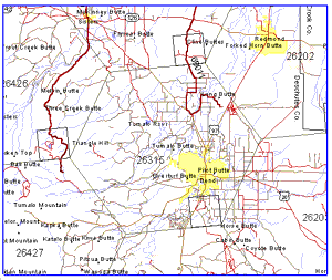
 This is a detailed hexagon map. You may find these detailed maps from several
places within the Atlas. When you pull up these maps, the context remains,
with links and descriptive information appropriate to the context from
which you called up this map. To explore
the hexagon further, use the Hex icon at the top of the screen.
Each hexagon
covers an area of 634.5 km2 (245 mi2, or 156,000 acres), has six sides each with a length
of 15.8 km (9.8 mi), and measures 27.4 km (17.0 mi) perpendicularly from side to side.
The map shows cities and towns in yellow. Rivers, streams, lakes,
reservoirs, and bays are shown in blue. Major highways are in black.
The outline of the square is in black, as are county boundaries.
Roads or paths covered by atlas observers
are shown in red. Breeding Bird Survey routes are shown in a heavier
red, with the route number. Very few secondary roads are shown;
thus you may see roads in red
that are disconnected from other roads. Red stippling shows other areas
covered by atlas observers. Not all observers reported roads or areas
covered; thus some coverage is not shown on these maps.
 This is a detailed hexagon map. You may find these detailed maps from several
places within the Atlas. When you pull up these maps, the context remains,
with links and descriptive information appropriate to the context from
which you called up this map. To explore
the hexagon further, use the Hex icon at the top of the screen.